The Maldives Space Research Organisation is taking a role to ensure that satellite technology serves the needs of small island developing states and ocean communities.
When the Space4Ocean Alliance launched at the UN Oceans Conference in Nice in June 2024, it marked a turning point for how the space and ocean communities work together. Among the founding members was the Maldives, a nation of low-lying islands with a space agency just three years old.
– The existing satellite technologies and services are heavily skewed towards large landmasses. It’s not at all optimized for small island states, coastal areas, or especially the wide ocean, says Madin Mohamed Maseeh, President of the Maldives Space Research Organisation (MSRO).
– There’s a need that the ocean community has that space can provide, but the two parties are not talking to each other. That’s what the alliance was founded on.
The Alliance, initiated by CNES (the French Space Agency) and joined by the UN Office for Outer Space Affairs, Monaco Space Office, and NOAA, attracted 33 government signatories at launch along with observers from industry and international organisations.
A Voice for Island Nations
For Maseeh, who serves as vice-chair of the Alliance, the Maldives’ role is about ensuring that the unique challenges of small island developing states and least developed countries are understood.
The problem is concrete. Many Maldivian islands are less than two square kilometres. When satellites pass 500 kilometres overhead at high speed, capturing accurate imagery is enormously difficult.
– The islands are either blurry or they’re skewed. There are many errors that we have to then come in and help fix, says Maseeh. The sensors are often designed to monitor forests or landmasses rather than ocean environments, lacking the spectral bands fine-tuned for marine applications.
– Commercial companies have built solutions like reef monitoring solutions that are, frankly, inaccurate. But there was no one to tell them that, Maseeh says. – We’ve been taking the responsibility of not just being a national space entity, but also representing the SIDS community.
From Noise to Intelligence
One of the alliance’s most significant potential contributions, Maseeh argues, is developing the first transshipment event detection standard. The transfer of catch between vessels at sea is a core mechanism enabling illegal fishing, yet it lacks a global operational definition or shared data schema.
– Even with illegal fisheries, there are so many questions that have not been answered, like how do we define what a transnational crime looks like on a satellite image. These are things the alliance can come in and help with, he says.
Currently, data from different sensors and providers don’t speak a common language.
– Intelligence without interoperability is not intelligence. It’s noise, says Maseeh. – And noise is expensive, especially for small island states with limited resources.
The goal is to move from “inconsistent dots on a map” to transparent, structured, court-ready intelligence.
Bridging Two Worlds
The Maldives brings a dual perspective to the Alliance.
– We are both an end-user as a SIDS country, but also because we are a space entity, we will either be collecting the data or we’ll be having our own asset soon. So we have the perspective from both ends, Maseeh explains.
This positions MSRO to bridge the gap between satellite providers and the communities they aim to serve.
– You can’t just do it with just the space component. You have to also bring in the ocean component. You have to validate the data to see if it’s working, he says. – We give the opportunity for space data to be validated, on top of bringing all the perspectives.
Tailored Solutions for Maritime Crime
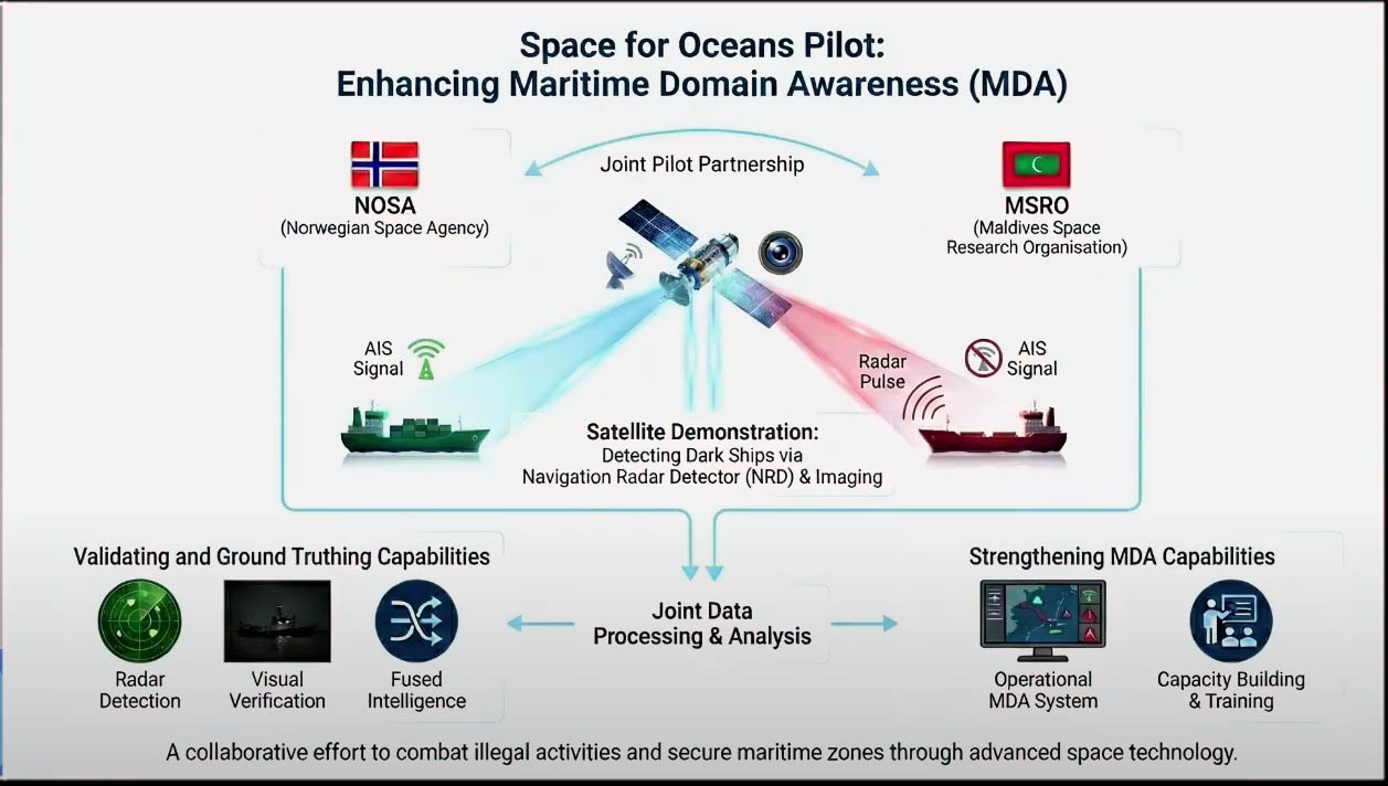
General-purpose satellite sensors generate vast amounts of data that island nations must process—often at great cost—to extract what they need. Maseeh points to a Norwegian-developed payload designed to detect ship navigation radar as an example of a more targeted approach.
– Having these tailored solutions means we get exactly what we need, he says.
Norway and the Maldives will launch a joint pilot to trial this navigational radar detection satellite system as a low-cost, non-cooperative surveillance layer, in collaboration with Maldivian fisheries authorities, coast guard, customs, and the ministry of transportation.
– This is not about a single country. This is a proof of concept for the alliance, says Maseeh. – If successful, it becomes a building block the alliance can scale to any nation.
The pilot reflects a core concern: that existing satellite technologies remain out of reach for the nations that need them most.
– Many satellite-based vessel tracking solutions were designed not with our realities in mind. They were built for large navies and well-resourced intelligence units, Maseeh explains. – At price points far beyond the reach of frontline nations like ours. When security becomes unaffordable, justice becomes optional.
This is where initiatives like Blue Justice fit in.
– Blue Justice definitely is a very tailored solution that goes beyond just the technology, says Maseeh. – You also need, especially for issues of transnational crime, the justice element to be first. Blue Justice solves the multi-agency collaboration problem primarily.
The Road Ahead
The Alliance’s first task is comprehensive mapping: identifying what technologies exist, what they can measure, and where the gaps lie.The solution may require purpose-built technology.
– We might go towards a world of tailored sensors for certain solutions, he says.
The next Alliance steering committee meeting will be held in late April in the Maldives. For a three-year-old agency, MSRO has quickly become a vocal actor in the space community.
– Our nations don’t ask for special treatment. What we ask for is fairness, visibility, and the ability to enforce our own laws in our own waters.